Boa Vista, Cape Verde
| Native name: Bubista Sobriquet: Ilha das dunas (island of the dunes) |
|
|---|---|
 |
|
 |
|
| Geography | |
| Location | Atlantic Ocean |
| Area | 620 km2 (239 sq mi) |
| Length | 31 km (19.3 mi) |
| Width | 29 km (18 mi) |
| Highest elevation | 387 m (1,270 ft) |
| Highest point | Monte Estância |
| Country | |
|
Cape Verde
|
|
| Concelhos (Municipalities) | Boa Vista |
| Largest city | Sal Rei |
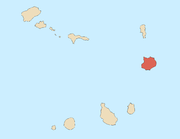
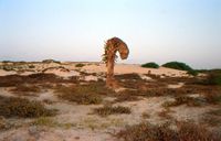
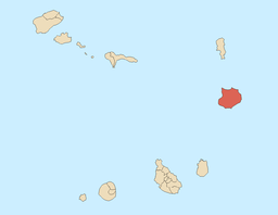
Boa Vista (Portuguese meaning “good view”) is the easternmost island of Cape Verde. It is located in the Barlavento group of the archipelago. The island is known for marine turtles and traditional music, as well as its ultramarathon and its sand dunes and beaches. The island also constitutes the municipality of Boa Vista, which has two parishes, Santa Isabel and São João Baptista
Contents |
Geography
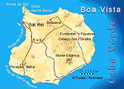
With an area of 620 km², it is the third largest island, after Santo Antão and Santiago. It is 455 km west of the coast of Africa. Much of the island is flat. The highest point on the island is Monte Estância, elevation 387 meters; other mountains include Santo António (Saint Anthony) and Monte Negro (Black Mountain). Other features include Campo da Serra. Its main town is Sal Rei, its ferry port and home to Boa Vista's airport (Rabil Airport)on the northwest side of the island.
Surrounding islets include Ilhéu de Sal Rei featuring a lighthouse in the west, and Ilhéu do Baluate featuring the easternmost point in Cape Verde. Points include Ponta Antónia to the north.
| Boa Vista | |
| Municipality | |
| Country | |
|---|---|
| Island | Boa Vista |
| Seat town | Sal Rei |
| Area | 620 km² (239 sq mi) |
| Population | 3,353 (2005) |
| Density | 5 / km² (13 / sq mi) |
| ISO 3166-2 code | CV-BV |
| CGN-CV code | 51 |
| Demonym | Boa-vistense m, ~s pl |
 |
|
| Website: http://www.anmcv.org/portugues/membro.php?id=boavista | |
Settlements

- Baforeira
- Cabeço dos Tarrafes
- Curral Velho
- Estância de Baixo
- Fundo das Figueiras
- Gata
- João Barreiro
- João Galego
- Norte
- Povoação Velha
- Rabil
- Sal Rei
- Santo Tirso
Population
While most of the population live in Sal Rei, there are many small settlements with 10 to 100 people; others are abandoned. It has the smallest population of all of inhabited Cape Verde’s islands, and it is the least-dense populated in the archipelago.
| Population of Boa Vista, Cape Verde (1940—2010) | |||||||
|---|---|---|---|---|---|---|---|
| 1940[1] | 1950[1] | 1960[1] | 1970[1] | 1980[1] | 1990[1] | 2000[2] | 2010[3] |
| 2779 | 2985 | 3263 | 3569 | 3372 | 3452 | 4209 | 6233 |
Economy
Its economy was originally based on agriculture, but desertification led to salt collection becoming more important. Its main industries today are date farming and, increasingly, tourism, with already several touristic establishments being built in recent times. A large 750-room RIU Hotels hotel (Riu Karamboa) has recently opened 5 km South of Sal Rei, having more rooms than all other tourist accommodation on Boa Vista combined. A further Riu with 2000 rooms is planned for the South of the island.
Sporting teams
- Academica (Sal-Rei) - Sal-Rei
- Académica Operária
- África Show
- Desportivo Estância Baixo
- Juventude do Norte
- Sanjoanense (Boa Vista)
Persons
- Aristides Pereira, Cape Verde's first president
- Germano Almeida, a Capeverdean writer [1]
Other
Boa Vista has a college (colegio), a middle school, high school, churches, beaches, a hotel, a port, and a square (praça).
References
External links
- information from BoaVistaExperience.com
- information on Boa Vista from CaboVerde.com
- French site with more than 2500 photos
- Maps of Boa Vista (scale: 1:50:000)
- Hiking Guide Boa Vista
- Informations about Cape Verde and Boa Vista
- Video in HD of Boa Vista island
|
|||||||||||||
|
||||||||